June 2, 2026

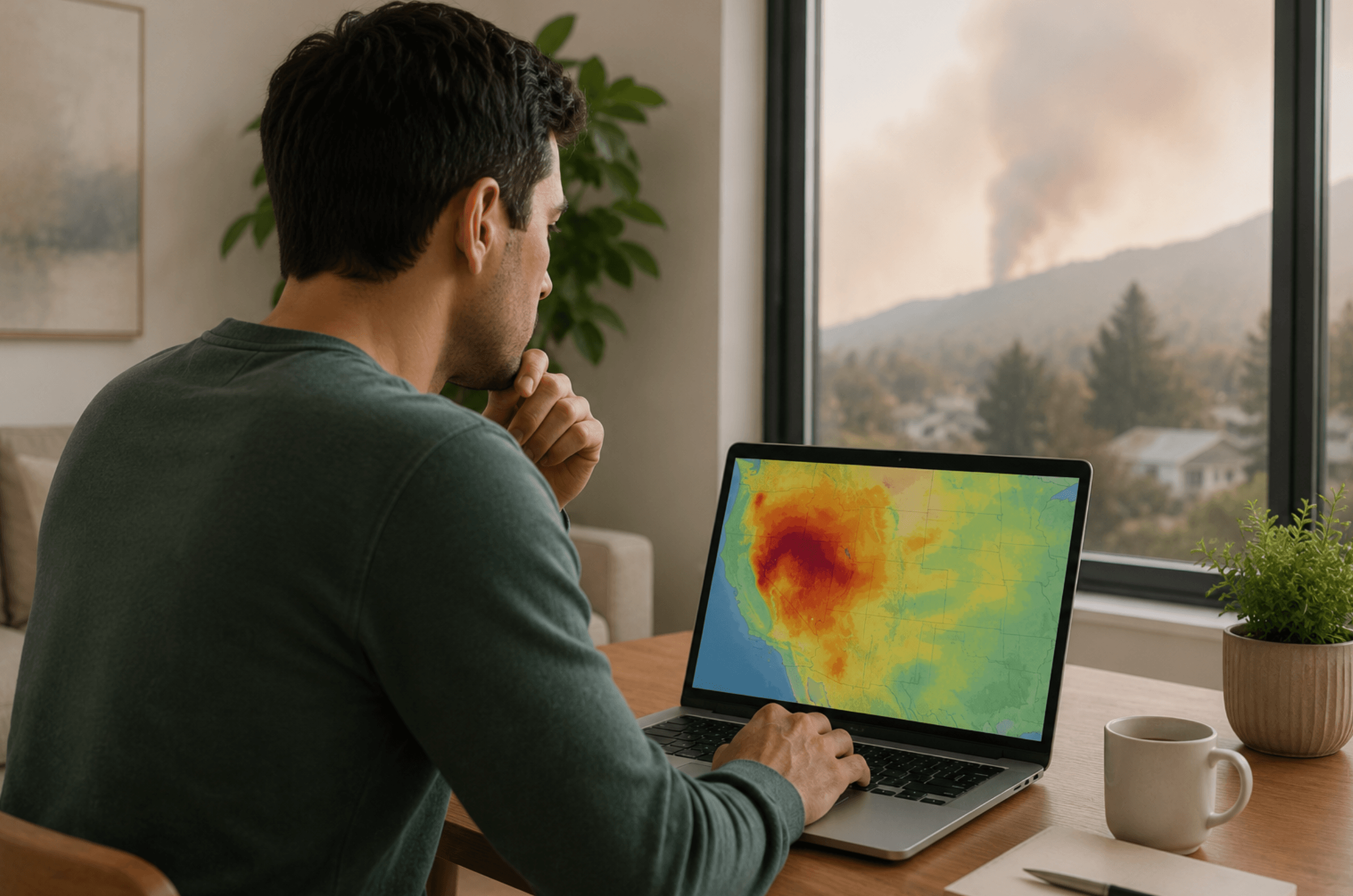
A wildfire smoke map can tell you in about thirty seconds whether it's safe to let the kids play outside. The catch is knowing which dot to read, what its color means, and whether that gray smudge overhead is smoke about to settle on your street.
Most people open the map, see a screen full of colored circles and little flame icons, and close it more worried than when they started. That's a shame, because the map is one of the most useful free tools you have during fire season. We've shipped filters to families through a decade of smoke events, and the households that stay comfortable indoors aren't the lucky ones. They learned to read the conditions, and they got their homes ready before the haze rolled in. This guide walks through both: how to read the AirNow Fire and Smoke Map, what the color scale means for the people in your house, and how to know when the air outside has cleared enough to open the windows again.
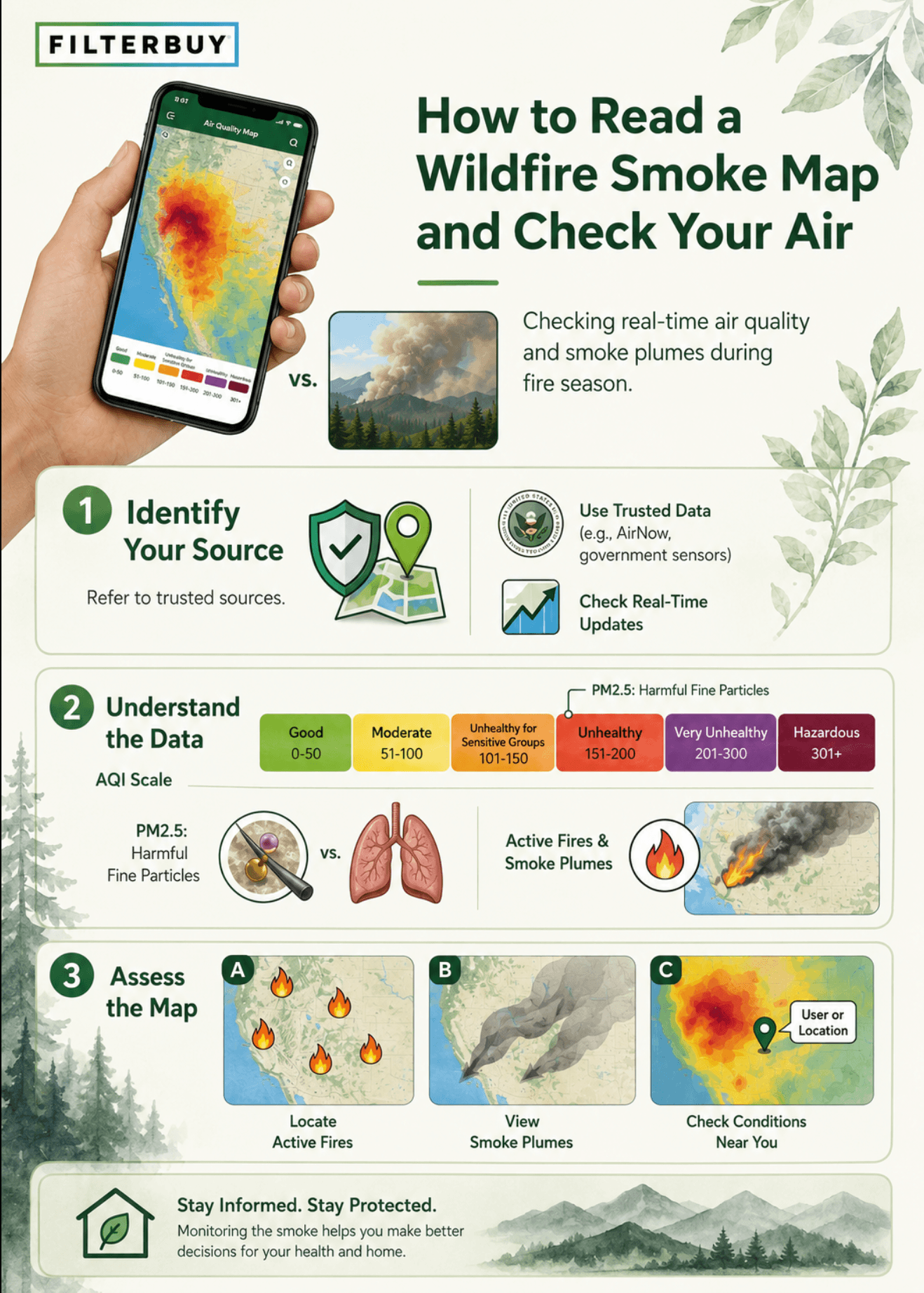
A wildfire smoke map is a free, live map that shows where wildfires are burning, where the smoke is drifting, and how clean or dirty the air is near you right now. The one we point families to is the AirNow Fire and Smoke Map. Find your spot, read the colored dot closest to you, and you have your answer in seconds.
A smoke map tracks PM2.5, the fine particle pollution in wildfire smoke, and shows it by location so you can tell when the outdoor air has turned unhealthy. Most maps pull live readings from official government monitors and neighborhood sensors. When two nearby readings disagree, trust the closer official monitor. When you're still unsure, act on the worse number.
The AirNow Fire and Smoke Map stacks three things in one view: flame icons for active fires, gray shading for drifting smoke plumes, and colored dots for real-time air quality. The EPA and U.S. Forest Service built it, and it refreshes about every hour. Green means clean air. Orange or worse means sensitive folks should head inside.
For today's conditions, open the AirNow Fire and Smoke Map and check the dot closest to you. It refreshes roughly every hour, so the reading reflects the air right now, not yesterday. On a fast-changing smoke day, watch the NowCast trend before you open windows or plan time outdoors
• The color is the answer. The scale runs green, yellow, orange, red, purple, maroon. Orange or worse means treat the day as a smoke day and adjust your plans.
• Lean on the official monitors. When a neighborhood sensor and a government monitor disagree, trust the monitor. If you still aren't sure, go with whichever reading is worse.
• Read the plumes and the trend, not just the dots. Plumes show smoke that hasn't reached you yet. The NowCast trend estimates the next few hours. Together they buy you a head start.
• A closed-up house still lets smoke in. Sealing the windows helps, but what your HVAC filter captures is what decides the air you actually breathe.
• Get ready before the smoke, not during. The families who breathe easiest stocked the right filters while the air was still clear.
A wildfire smoke map pulls together where the air is bad, where fires are burning, and where the smoke is heading. The most reliable one is the AirNow Fire and Smoke Map, run jointly by the EPA and the U.S. Forest Service. The part people miss: it measures PM2.5, the fine particle pollution that does the real damage in smoke. It isn't tracking every pollutant. It's tracking the one that matters most when the air turns brown.
1. Find your location. Let the map use your location, type in a place name, or zoom to your block.
2. Read the dot nearest you. Every dot is a current reading, colored by category. That color is your quick answer.
3. Check the shape. Circles are permanent government monitors and the most accurate. Other markers are temporary monitors and lower-cost crowdsourced sensors. The map corrects sensor data for accuracy, but when two nearby readings clash, trust the closest monitor.
4. Find the fire icons. Flame markers show where fires are burning across North America.
5. Watch the smoke plumes. The gray shaded areas show smoke drifting overhead, so you can see what's coming before it lands.
6. Look for a pink Smoke Outlook banner. On bigger fires, it links to an official forecast for the days ahead. Tap it.
7. Read the trend. The NowCast number estimates the next few hours if conditions hold. On a shifting smoke day, that's the one to watch.
• Green, AQI 0 to 50, Good. Air is clean. Carry on.
• Yellow, AQI 51 to 100, Moderate. Fine for most. Unusually sensitive folks, watch for symptoms.
• Orange, AQI 101 to 150, Unhealthy for Sensitive Groups. Kids, older adults, and anyone with asthma or heart conditions should limit time outside.
• Red, AQI 151 to 200, Unhealthy. Everyone cuts back on outdoor activity. Keep the windows closed.
• Purple, AQI 201 to 300, Very Unhealthy. Stay indoors and run your HVAC with a clean filter.
• Maroon, AQI 301 to 500, Hazardous. Emergency conditions. Stay inside with filtered air.
The number to remember is 100. Below it, you have room to breathe. At 101 and up, the air starts working against the most vulnerable people in your home.
Smoke shifts by the hour, so don't trust the morning reading to hold all afternoon. Check the trend again before you head out. And remember that even after the map outside turns green, fine particles can hang around indoors for a while. The map answers one question, about the air beyond your walls. What's happening inside is a separate one.
This is the part most people overlook. Your smoke map reads outdoor conditions, and smoke doesn't politely wait at the door. It works its way in through gaps, windows, and your ventilation. Once the map goes orange, your HVAC filter becomes your home's first line of defense.
That's the moment the right filter pays for itself. The EPA points homeowners to MERV 13 for smoke, because it's the lowest household rating that meaningfully traps PM2.5, the particle that defines wildfire smoke. A few moves that work well together:
• Put in a MERV 13 before fire season, not in the middle of it.
• Run the HVAC fan on ON instead of AUTO so air keeps cycling through the filter.
• Set up one clean room with the fewest windows, and keep a box-fan-and-filter air cleaner ready as a low-cost backup.
• Check the filter about every 30 days during smoke season. They fill up fast, and a clogged filter stops doing its job.
• For the campfire smell that lingers after the worst passes, an Odor Eliminator filter with activated carbon catches what a standard filter can't.
"We've built filters in the USA for more than a decade and talked with families in the thick of active fire seasons. The ones who feel safe inside on a smoke day put a MERV 13 in before the map ever turned orange. Reading the map is step one. Already having the right filter in your system is what turns that reading into something you can act on."
— Filterbuy Tetam
Verified, authoritative sources, each from a different organization.
• AirNow Fire and Smoke Map: The gold-standard live map from the EPA and U.S. Forest Service. Real-time PM2.5 readings, fire locations, smoke plumes, and Smoke Outlooks in one view.
• EPA, Learn About Wildfires and Indoor Air Quality: Official guidance on keeping smoke out of your home, including how to set up a clean room and which filter to use.
https://www.epa.gov/emergencies-iaq/learn-about-wildfires-and-indoor-air-quality
• CDC, Staying Safe During a Wildfire: Health-focused safety steps, a symptom watch-list, and what to do before, during, and after a fire.
https://www.cdc.gov/wildfires/safety/how-to-safely-stay-safe-during-a-wildfire.html
• PurpleAir Map: A dense network of neighborhood sensors that often catches local smoke faster than official monitors. Handy for cross-checking your AirNow reading.
• NOAA Storm Prediction Center, Fire Weather Outlook: Daily maps of elevated, critical, and extreme fire-weather risk, so you can see conditions building before a fire starts.
https://www.spc.noaa.gov/products/fire_wx/
• American Lung Association, Wildfires: A clear, medically grounded explanation of how smoke affects your lungs and who's most at risk.
https://www.lung.org/clean-air/emergencies-and-natural-disasters/wildfires
• InciWeb, Incident Information System: The national clearinghouse for active wildfire incident details, maps, and updates.
Each figure links to a separate, reader-accessible source.
• Wildfire smoke has slowed or reversed clean-air progress in 35 states, wiping out about a quarter of the air-quality gains those states made since 2000. Smoke has become one of the biggest air-quality stories of the decade.
Source: Stanford University, https://news.stanford.edu/stories/2023/09/wildfire-smokes-toxic-influence
• Long-term exposure to wildfire smoke PM2.5 is linked to roughly 11,400 deaths a year in the contiguous U.S. These particles are far more than a nuisance. They carry a real, measurable health toll.
Source: Yale School of Public Health, https://ysph.yale.edu/news-article/long-term-exposure-to-wildfire-smoke-associated-with-higher-risk-of-death/
• Even with the windows and doors closed and no air cleaner running, indoor air during a smoke event still holds about 55 to 60 percent of the outdoor particle level. Sealing up the house isn't enough on its own. What your filter does with that air is what counts.
Source: U.S. EPA, https://www.epa.gov/wildfire-smoke-course/strategies-reduce-exposure-indoors
A smoke map is one of the best free tools you'll ever bookmark, and it still does only half the job. It tells you what the air is doing to you. It can't do anything for you.
Here's our honest read after years of fire seasons. Checking the map is a good habit, but it tends to put people in react mode, refreshing the screen and hunting for filters that just sold out. The families who handle smoke season calmly flipped that around. They treat the map like a quick weather check, and they made the one change that improves their indoor air long before they needed it. That's the difference between watching the smoke and breathing easy through it.
1. Bookmark your local view of the AirNow Fire and Smoke Map so you can pull it up in two taps.
2. Make it routine: a quick check in the morning, and another before you open any windows.
3. Know your filter size and rating. If you're running below MERV 13 heading into fire season, that's the upgrade to make now.
4. Read the full home playbook in our guide on protecting your home from wildfire smoke.
5. Stock up while the air is still clear, so you're not searching for filters the day the smoke arrives.
A free interactive map from the EPA and U.S. Forest Service. It shows live PM2.5 air quality readings, where fires are burning, and how smoke is moving across North America, all in one place.
Open the map and let it use your location, or search your city or ZIP. The colored dot closest to you shows your current air quality.
They follow the Air Quality Index: green is good, yellow is moderate, orange is unhealthy for sensitive groups, red is unhealthy, purple is very unhealthy, and maroon is hazardous. Orange or worse is your cue to get sensitive family members inside.
About every hour, as fresh readings come in, so a check today reflects today. During a fast-moving event, keep an eye on the NowCast trend for what's coming next.
At 101 and up, children, older adults, and people with asthma or heart conditions should cut back on time outside. At 151 and up, everyone should limit outdoor activity and keep the windows closed.
No, only outdoor conditions. Smoke gets into homes, and indoor particle levels can stay high even after the outdoor reading improves. That's why your filter, and how you run your system, matters so much.
MERV 13 or higher. The EPA recommends it because it's the lowest household rating that captures PM2.5, the fine particle that defines wildfire smoke. Lower ratings like MERV 8 are built for dust and lint, so smoke slips right through.
When the AQI climbs, your filter is what stands between outdoor smoke and the air your family breathes. We make MERV 13 filters in over 600 sizes, build them in the USA, and ship them factory-direct, fast and free.
Find your exact size and move up to MERV 13 before the next smoke event.
Set up auto-delivery so a fresh filter shows up right when it's time to swap. No store runs, no scrambling.