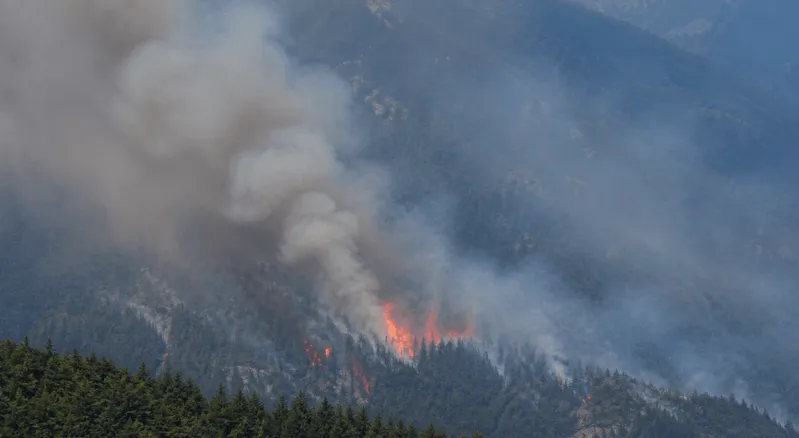
Your eyes start watering on the morning walk. The light over the Charles looks wrong. By the time you smell it, smoke from a wildfire 800 miles away has already moved through your storm windows, your HVAC return, and into the air your kids breathe at the kitchen table. The current wildfire map below tracks Boston's air in real time. By the time you smell smoke, your family has been breathing it for hours.
At Filterbuy, we are obsessed with what is actually in your air. The live tracker pulls wildfire data across the Northeast and refreshes during active events. Use it to see where fires are burning, then watch how smoke is drifting toward Greater Boston. Whether you are checking before a morning run along the Charles or wondering if it is safe to send the kids to recess, you can see what your family is breathing right now and decide what to do about it.
Live tracking: The map above shows current PM2.5 readings, smoke plume location, and active fire markers across Boston, the North Shore, the South Shore, and the Berkshires.
Best ongoing source: EPA AirNow's Fire and Smoke Map updates continuously and is the source most local agencies cite during smoke events.
What actually protects your indoor air: Close windows, switch the HVAC fan to On, verify your MERV 13 filter is clean, and run a portable HEPA cleaner in any bedroom your kids sleep in.
Why this matters in Boston: We sit downwind from one of the most active smoke transport regions on the continent. Wildfire smoke from Quebec, Ontario, or central Massachusetts reaches Greater Boston within 12 to 36 hours of release.
Boston sits downwind of the Northeast's most active smoke transport corridor. Quebec, Ontario, and Maritimes fires drive most of the city's heavy smoke days, with a 12 to 36-hour arrival lag after the plume launches.
Take action at AQI 100. Indoor PM2.5 starts climbing once outdoor air crosses Moderate, and waiting for an Unhealthy reading lets damage compound through your HVAC by the time you act.
MERV 13 is the floor for smoke filtration. PM2.5 particles are 2.5 microns and smaller, so lower-rated filters let smoke pass through your HVAC and recirculate through your home for days.
HVAC fan setting matters as much as filter rating. The Auto setting only runs the fan when the system is actively heating or cooling, while On runs it continuously and pulls air through the filter even when the temperature is steady.
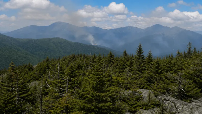
Boston brush fires drive local smoke alerts, too. October 2024 saw four dozen Massachusetts brush fires in one weekend with North Shore advisories. Local forest fires near Boston today show on the map above.
The map above tracks active fires, smoke plume drift, and live AQI sensor readings across Greater Boston, the North Shore, the South Shore, Worcester County, and the Berkshires. Each colored circle is a live monitor reading on the EPA Air Quality Index scale. Gray plume overlays show where smoke is moving at the surface, and red flame markers locate active fires. Smoke from fires in Quebec, Ontario, the Maritimes, and central or western Massachusetts can reach Greater Boston within 12 to 36 hours, depending on wind direction and any atmospheric inversion sitting overhead.
For deeper conditions analysis pulled from MassDEP regulatory monitors, cross-reference your live findings with Boston's live AQI map, which tracks ozone, PM2.5, PM10, nitrogen dioxide, and other pollutants separately.
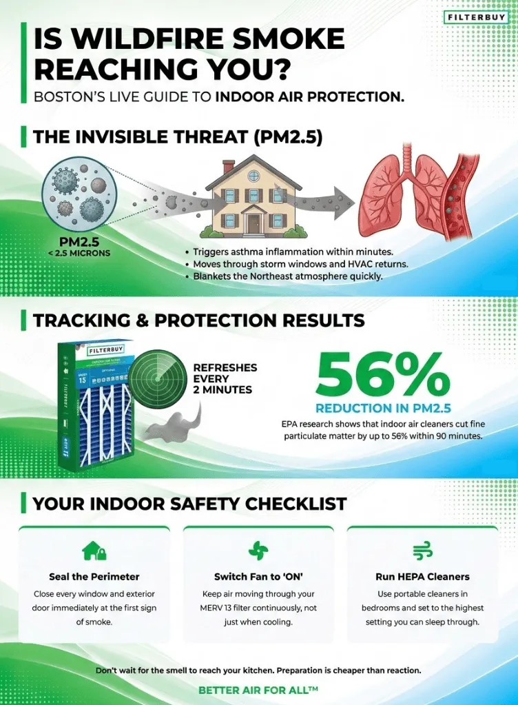
The real-time smoke map for Massachusetts and the Boston area pulls from regulatory monitors and PurpleAir sensors that refresh every two minutes during active events. PM2.5 is the dominant pollutant tracked here. Particles smaller than 2.5 microns penetrate deep into the lungs, cross into the bloodstream, and trigger the kind of inflammation that asthma patients feel within minutes. When you check the map, look at the AQI band at your nearest monitor first. The dashboard popup also shows whether a gray smoke plume is sitting overhead, and a trend arrow tells you if air is improving or worsening from the previous hour. The Boston smoke forecast can shift sharply once an inversion sets up. Recheck every two to three hours during active events.
Boston's heaviest smoke days usually arrive on long-range Canadian transport, but local brush fires across Essex County, Middlesex County, and the Quabbin Reservoir region produce their own alerts during dry windows. October 2024 made the point clearly. In a single weekend, Massachusetts saw nearly four dozen brush fires, and North Shore towns, including Salem, Middleton, and Lynn, issued local air quality alerts. Check the fire markers on the map for active local activity, then cross-reference NWS Boston for any open advisories affecting your zip code.
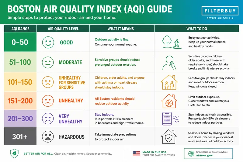
Each AQI category band has a specific action threshold for Boston households.
After manufacturing filters for over a decade and serving more than two million households, we have seen what separates a forgettable smoke event from one your family suffers through. The difference comes down to how fast you react and what is already sitting inside your HVAC when smoke arrives. The Boston households that barely notice a Canadian transport day all share one pattern. Their fan was already on the moment a plume showed on the map, and their MERV 13 filter had been installed clean back in March, not in a panic the day the AQI hit 150. By the time the smoke smell reached the kitchen, the filter was already pulling it back out.”
— Filterbuy Team
These seven sources cover live tracking, regional forecasts, health guidance, and academic research on wildfire smoke. Every link below was verified live the week this page was published.
The federal standard for live wildfire smoke tracking is run jointly by the U.S. EPA and the U.S. Forest Service. The map pulls PM2.5 readings from more than 1,700 regulatory monitors and adds low-cost sensor data on top, refreshing continuously during active events. Click any monitor for current AQI, recent trend, and recommended health actions.
Source: https://fire.airnow.gov/
The Massachusetts Department of Environmental Protection runs more than 20 monitoring stations statewide and added new stations in Framingham and Saugus in 2025. The MassDEP page covers the state air sensor grant program and links to MassAir Online, which tracks Boston-area readings through the day.
Source: https://www.mass.gov/info-details/air-sensors-for-particulates
The official NWS forecast office serving eastern Massachusetts, southern New Hampshire, and Rhode Island. NWS Boston issues air quality alerts when forecasters expect smoke or particulate concentrations to reach unhealthy levels, and most local news outlets cite this office during smoke events.
Source: https://www.weather.gov/box/
The Centers for Disease Control and Prevention publishes detailed guidance on protecting yourself, your family, your pets, and your home during a wildfire smoke event. The CDC page covers respirator selection, clean-room setup, and evacuation triggers. It also breaks out specific precautions for children, older adults, pregnant residents, and people with chronic conditions.
Source: https://www.cdc.gov/wildfires/safety/how-to-safely-stay-safe-during-a-wildfire.html
The American Lung Association's annual State of the Air report grades every Massachusetts county on ozone and particle pollution. The state page tracks Greater Boston, Worcester County, the North Shore, and the Berkshires across multi-year trends, which lets you compare wildfire smoke years against non-smoke years directly.
Source: https://www.lung.org/research/sota/city-rankings/states/massachusetts
Harvard's C-CHANGE center publishes ongoing research on how climate change is driving wildfire smoke health impacts across the U.S. The most recent attribution work quantifies climate change's contribution to wildfire PM2.5 at the state and county level, including findings specific to the Northeast.
NASA's Fire Information for Resource Management System uses MODIS and VIIRS satellite data to detect active fires globally, including burning fires in Quebec, Ontario, and the Maritimes that drive smoke transport into New England. The map updates every three hours and is the source EPA pulls from for the AirNow Fire and Smoke Map fire markers.
Source: https://firms.modaps.eosdis.nasa.gov/map/
Federal and academic data tell a clear story about how wildfire smoke affects Boston-area households and what indoor protection can actually achieve. The findings below all come from page-level sources, each verified live the week this page was published.
EPA researchers tested a properly built do-it-yourself air cleaner during a real wildfire smoke event and watched indoor PM2.5 drop by about 56% in a larger room within 90 minutes, and by about 99% in a smaller room within 60 minutes (May et al., 2021). We see the same pattern across our Boston customer base. Households that pair a clean MERV 13 HVAC filter with a portable HEPA unit in the bedroom see indoor PM2.5 stay flat while their neighbors complain about itchy eyes.
Source: https://www.epa.gov/wildfire-smoke-course/strategies-reduce-exposure-indoors
A 2025 cohort study indexed in PubMed measured what wildfire smoke does to older adults during a single event. When smoke PM2.5 rose from 0 to 40 µg/m³ over the same day and the preceding week, daily respiratory hospitalizations increased by 2.40 per 100,000. For Greater Boston households with a parent or grandparent at home, this matters during every Canadian transport event. Even a few days of moderate exposure measurably raise the odds of an emergency room visit.
Source: https://pubmed.ncbi.nlm.nih.gov/40305019/
NOAA atmospheric scientists tracked the 2020 wildfire season as the unprecedented event it was. NOAA aircraft sampled smoke from West Coast fires more than 1.5 miles above ground near Baltimore, Maryland, measuring 62 µg/m³ inside the elevated plume. That layer sat too high to pose a direct ground-level health risk in Boston. But the measurement shows how completely a single fire season on the other side of the continent can blanket the Northeast atmosphere.
Source: https://www.arl.noaa.gov/news-photos/noaa-nesdis-and-oar-team-up-to-trace-wildfire-smoke/
Boston is not a wildfire city the way Sacramento is. We sit downwind from one of the most active fire smoke transport regions on the continent, and we have our own seasonal brush-fire windows in spring and fall. Smoke from a fire 800 miles north of the Charles River will still find your bedroom by Tuesday afternoon if the wind is right.
Understanding how wildfires spread and how their smoke moves across regions changes how you protect your home. The map above shows you what is happening right now, while the resources and statistics here tell you what that smoke does once it crosses your threshold. Filterbuy's job is to make sure your filter is already doing the work when the wind shifts.
The pattern we see across smoke seasons is consistent. Boston families who barely notice a heavy Canadian transport day are the ones who installed a fresh MERV 13 filter in March, who know exactly where their portable HEPA unit is stored, who flip the HVAC fan to On the first time the AQI crosses 100, and who close their windows before the smell reaches the kitchen. The families who get caught flat-footed wait for the news to tell them it was bad. By then, it is already inside the house. Preparation is cheaper than reaction.
Close every window and exterior door at the first sign of smoke or an air quality alert. Outdoor smoke gets inside within minutes, and prevention is faster than removal once particles are circulating.
Switch your HVAC fan from Auto to On so air keeps moving through your filter continuously, not only when the system is heating or cooling.
Pull your current filter and check it. If it is gray, three months old, or rated below MERV 13, replace it now. Old or low-rated filters let fine smoke particles slip past and recirculate every time the fan kicks on.
Run a portable HEPA air cleaner in the bedroom and in any room where children, older adults, or anyone with asthma spends time. Set it to the highest setting you can sleep through.
Sign up for MassDEP and AirNow alerts so you get a heads-up the next time smoke is forecast over Boston, before you smell it.
Check the live map at the top of this page for current PM2.5 readings at monitors across Greater Boston.
Look at your closest monitor for street-level air conditions
If the trend arrow is climbing, close windows and switch your HVAC fan to On
Cross-reference NWS Boston for any open advisories
The fire markers on the live map show active fire detections from NASA satellites and ground reports. Boston's most frequent smoke source is long-range Canadian transport rather than nearby fires.
Quebec and Ontario fires drive most heavy smoke days in Boston
Local Massachusetts brush fires cluster across Essex County, Middlesex County, and the Quabbin region
The map updates as new detections come in throughout the day
Smoke plumes from Quebec and Ontario fires ride upper-level winds southeast across New England, often arriving in Greater Boston within 12 to 36 hours of release. The plume can travel at any altitude. Surface plumes trigger AQI alerts. Plumes that stay aloft cause hazy skies without setting off ground monitors. Wind direction and any atmospheric inversion overhead determine how much actually reaches the ground in your neighborhood.
Outdoor exertion gets risky once the AQI passes 100, and unsafe for everyone above 150.
Below 50 (Good): normal outdoor activity is fine
51 to 100 (Moderate): sensitive groups should reduce prolonged outdoor exertion
101 to 150 (Unhealthy for Sensitive Groups): children, older adults, and those with asthma should stay indoors
Above 150 (Unhealthy): everyone should reduce outdoor activity and close windows
MERV 13 is the recommended filter for capturing wildfire smoke particles. Higher MERV ratings remove more, but require an HVAC system designed for the increased airflow resistance.
MERV 13 captures PM2.5 down to 0.3 microns at meaningful efficiency
MERV 8 lets most fine smoke particles pass through
HEPA filtration in portable units captures even smaller particles in the room where it runs
Yes. Switching the fan from Auto to On runs the fan continuously and pulls air through your filter even when the system is not actively heating or cooling. This is one of the highest-impact actions you can take during a smoke event in Boston, especially if your filter is rated MERV 13 or higher.
With windows closed, an HVAC fan running, and a clean MERV 13 filter, indoor PM2.5 typically drops within hours of outdoor levels improving. A portable HEPA unit speeds the recovery in the room where it runs.
Without filtration, indoor levels can stay elevated for 24 to 48 hours
A DIY box-fan filter unit also works in a pinch
Check your nearest monitor before opening windows again
The map above tells you when smoke is reaching Boston. Filterbuy makes sure you are already ready when it does. We manufacture MERV 13 air filters at five U.S. facilities and ship them factory-direct to your door at the price the factory ships them, without markups, middlemen, or a panicked search the day the AQI hits 150.