Current Massachusetts Fire Locations & AQI Levels
Don't take Massachusetts air for granted on a smoke day. The hazy orange sun over Boston Harbor in June 2023 looked harmless from a distance, but the filters our customers shipped back to us that month told a different story. Some came back nearly black after two weeks of service. Others arrived loaded with the gray-brown residue we later learned signaled Saskatchewan wildfire ash that had traveled almost 2,000 miles south. After manufacturing filters for over a decade and serving more than two million households, we've learned that the worst threats to your family's air are the ones you can't see arriving. The live Massachusetts wildfire smoke map below shows you what's actually heading your way. Real-time EPA data plus crowd-sourced sensors cover every county. Scroll past the map for active fire locations, the Canadian smoke trajectory affecting New England this week, and what your filter is up against right now.
The EPA Fire and Smoke Map (fire.airnow.gov) provides the most granular wildfire smoke tracking, combining official monitors with 15,000+ sensors. EPA AirNow Massachusetts (airnow.gov/state/?name=massachusetts) covers official AQI readings from 20+ state monitors. MassDEP at mass.gov/air-monitoring-in-massachusetts handles county-level forecasts and burn advisories.
Check the EPA AirNow Massachusetts state page for your zip code. AQI above 100 means sensitive groups should limit outdoor activity. AQI above 150 means everyone should reduce outdoor exertion. Western Massachusetts (Berkshire, Franklin, Hampshire, Hampden, and Worcester counties) typically sees the highest readings during Canadian smoke events.
Six actions cover the bases: check your filter, run your HVAC fan continuously, seal air leaks, upgrade to MERV 13 if you're below it, keep replacements stocked, and limit outdoor activity for sensitive groups.
Pro Tip: Bookmark the EPA AirNow Massachusetts page and sign up for EnviroFlash alerts for your zip code. You'll know smoke is arriving before haze appears in the sky.
Massachusetts gets hit by smoke from two sources at once. Canadian wildfire smoke arrives via upper-level winds, while in-state brush fires drive localized spikes. Treat them as separate threats with overlapping protection strategies.
The current wildfires in Massachusetts map and the broader smoke trajectory both matter. The DCR tracks active in-state fires, and the EPA Fire and Smoke Map shows transported smoke. Use both together for the full picture.
Western Massachusetts feels the smoke first. Berkshire, Franklin, Hampshire, and Hampden counties typically receive MassDEP advisories before Worcester County and Greater Boston, so plan accordingly if you live in those areas.
MERV 13 is the right standard during Northeast smoke events. Lower ratings let PM2.5 pass through, and upgrading once means you don't have to scramble during the next alert.
The 90-day filter rule doesn't apply when smoke is in the air. Check weekly during active events, replace when visibly loaded, and trust the filter itself to tell you when it's time.
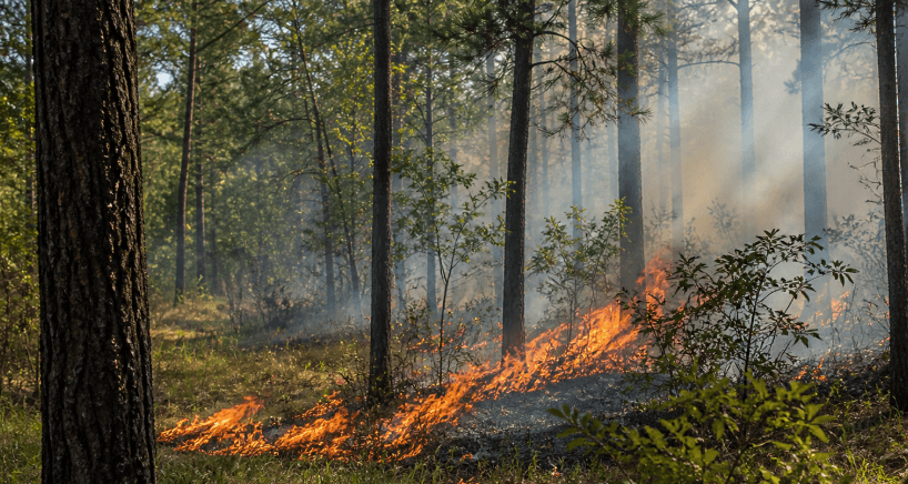
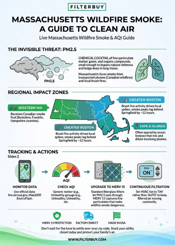
Wildfire smoke is a chemical cocktail. It carries fine particulate matter (PM2.5), gases, water vapor, and organic compounds released by forests, grasslands, and brush fires. Those particles measure smaller than 2.5 micrometers, small enough to slip past the body's natural defenses and lodge deep in lung tissue. Massachusetts faces two sources at once. In-state brush fires burn close to ground level and create localized smoke pockets across single counties. Transported smoke from Canadian wildfire activity crosses thousands of miles at higher altitudes and settles into a haze that can cover the entire Commonwealth for days at a time.
The science of wildfire activity, including ignition causes, fuel behavior, and smoke chemistry, has filled academic research libraries for decades. The brush fire patterns we see across Massachusetts each spring fit the same fundamental drivers as the larger fires out West, scaled to our forested landscape and population density.
The EPA's Air Quality Index translates pollutant readings into a 0-to-500 scale. Six color-coded categories tell you what the air outside means for your family during an active smoke event.
Good (0–50, Green): Air quality poses minimal risk to anyone, and routine outdoor activity is fine.
Moderate (51–100, Yellow): Sensitive groups may notice mild irritation, and anyone with asthma should keep medication accessible.
Unhealthy for Sensitive Groups (101–150, Orange): Children, older adults, and people with heart or lung conditions should reduce prolonged outdoor exertion.
Unhealthy (151–200, Red): Everyone faces some risk, and sensitive groups should stay indoors while you run your HVAC fan continuously to keep filtered air moving.
Very Unhealthy (201–300, Purple): Avoid outdoor activity altogether, seal windows and doors, and check filters daily until conditions clear.
Hazardous (301–500, Maroon): Emergency conditions that require staying indoors and replacing any heavily loaded filter as soon as a clean one is on hand.
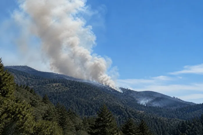
Most smoke events that affect the Commonwealth originate from Saskatchewan, Alberta, and Quebec. Upper-level atmospheric winds carry plumes nearly 2,000 miles south into New England, often in concentrated waves that produce hazy skies and elevated PM2.5 readings within 24 to 48 hours of arrival. The June 2023 event, the August 2024 advisory, and the August 2025 alert all followed this trajectory. The Massachusetts Department of Environmental Protection issues county-specific air quality alerts when forecast models project unhealthy concentrations. The Canadian wildfire smoke map, Massachusetts residents check most often pairs the EPA Fire and Smoke Map with the MassDEP forecast portal, and that combination gives you the clearest picture of when smoke arrives, how dense it gets, and when it lifts.
The DCR Bureau of Forest Fire Control responds to brush fires year-round, with peaks in spring (April through June) and fall (October through November). The 2024 fall brush fire season set records for active incidents on the North Shore and across Middleton. Recent activity in Greenfield, Southwick, and Ludlow during the 2026 dry spring has produced localized smoke impacts that don't always show up on the national New England wildfire smoke map view. A Massachusetts brush fire today often appears on the DCR live operations dashboard before national platforms catch up, which is why local sources matter alongside the bigger picture.
Western Massachusetts (Berkshire, Franklin, Hampshire, Hampden counties): Receives Canadian smoke first. The western Massachusetts smoke map readings often post advisories before Greater Boston sees haze, and Berkshire County wildfire smoke alerts run particularly high during Saskatchewan and Alberta fire surges.
Worcester County and Central Massachusetts: Frequently included in MassDEP advisories. The Worcester, MA smoke map readings typically lag eastern Massachusetts by 6 to 12 hours, and Worcester County's particle pollution grade has dropped in recent State of the Air reports.
Greater Boston and the North Shore: Brush fire activity drives most local spikes. Wildfire smoke in Boston today often arrives later than in western counties during Canadian events, and Boston air quality wildfire smoke readings typically peak about 12 hours behind Springfield.
Cape Cod and the Islands: Often spared from the worst smoke because ocean breeze patterns mix and dilute incoming plumes before they settle.
For statewide hourly updates and zip-code-level readings beyond the wildfire-focused tools, check the live Massachusetts AQI map maintained alongside this resource.
Outdoor smoke moves indoors continuously. Air slips through gaps around windows and doors, through HVAC fresh-air intakes, through cracks in older building envelopes, and even through some wall cavities. PM2.5 particles bypass standard fiberglass panel filters and settle on furniture, textiles, and lung tissue alike. Filters our Massachusetts customers returned during the 2023 Canadian wildfire smoke event came back with distinctive gray-brown discoloration after just two to three weeks of use. That's a small fraction of their expected service life, and it tells you exactly what your family would have been breathing without filtration in place.
Once the alert posts for your county or you can see haze settle in, six actions matter most:
Check your current filter immediately. Hold it up to a light source. If light doesn't pass through cleanly, or if the surface shows visible discoloration, replace it before the smoke event peaks.
Run your HVAC fan continuously. Set the fan to “on” rather than “auto” so air keeps moving through the filter even when heating or cooling isn't actively running.
Seal obvious air leaks. Roll towels under exterior doors that don't seal tightly, close fireplace dampers, and shut any windows with gaps.
Upgrade to MERV 13 if you're below it. MERV 13 captures the fine particulates that make wildfire smoke dangerous, and lower MERV ratings let those particles pass straight through.
Keep replacement filters on hand. Demand spikes during regional smoke events, and shipping delays can compound when you most need protection.
Limit outdoor activity for sensitive groups. Follow EPA guidance for the AQI level posted in your area.
“After analyzing thousands of filter returns from Massachusetts homes during the 2023 Canadian wildfire smoke event, we saw filters come back nearly black after just two weeks of use. That visible evidence is a direct readout of what your family would have been breathing without filtration in place. When smoke arrives, your filter becomes the most important system in your home.”
— Filterbuy Team
These seven verified resources give Massachusetts residents the tools to monitor live conditions, receive county-specific alerts, and understand long-term air quality trends. We've vetted each one against what our customers actually pull up during active smoke events.
The EPA partnered with the U.S. Forest Service to combine official monitor data with thousands of crowd-sourced sensors. The result is the most granular near-real-time view of wildfire smoke movement available, with filterable layers for fire perimeters, smoke density, and current AQI readings. Our customers tell us this is the first map they pull up when they spot haze on the horizon, and it's the closest thing to a live wildfire map Massachusetts users can access without installing additional apps.
Source: https://fire.airnow.gov/
The Centers for Disease Control and Prevention publishes the federal health protocol that emergency managers and pediatricians lean on during active smoke events. The page covers respirator selection, when staying indoors makes the difference, how to set up a clean room with portable filters, and chronic-condition-specific protocols for asthma, COPD, heart disease, diabetes, and pregnancy. We point Massachusetts families here when they want medical authority alongside the local AQI numbers.
Source: https://www.cdc.gov/wildfires/safety/how-to-safely-stay-safe-during-a-wildfire.html
The National Weather Service Boston office covers Massachusetts, Connecticut, and Rhode Island, and issues the Air Quality Alerts that go out when forecast smoke pushes AQI into unhealthy territory. The page also publishes fire weather forecasts that flag dry conditions ahead of brush fire risk across the Commonwealth, which gives you advance notice before the spring and fall fire seasons spin up.
Source: https://www.weather.gov/box/
Since 1911, the Bureau of Forest Fire Control and Forestry has coordinated wildfire prevention, detection, and suppression across the Commonwealth's 3.2 million acres of forest land. The page details current fire conditions, prescribed burn schedules, and the 13 fire districts that respond to brush fires statewide. This is the closest equivalent to a Massachusetts wildfire tracker for in-state activity, paired with the DCR's Massachusetts brush fire map for local incidents.
Source: https://www.mass.gov/orgs/bureau-of-forest-fire-control-and-forestry
The National Interagency Fire Center publishes daily updates on fires nationwide, the current National Preparedness Level (1 through 5), and active large-fire incidents by state. When Canadian smoke is in the forecast, NIFC's national context helps you see how wide the impact runs and which regions are driving the smoke transport you're watching on the Massachusetts fire map today.
Source: https://www.nifc.gov/fire-information/nfn
EnviroFlash is the EPA-supported notification system that sends free alerts when air quality is forecast to reach unhealthy categories. Sign up once with your Massachusetts zip code, and you'll receive direct warnings before haze arrives instead of finding out from a friend or the morning news. Setup takes under two minutes.
Source: https://www.enviroflash.info/signup.cfm
The annual State of the Air report grades every Massachusetts county on ozone, year-round particle pollution, and short-term particle pollution. The 2026 edition shows the long-term effect of wildfire smoke seasons on the Boston-Worcester-Providence metro area's air quality grades, with not a single Massachusetts county earning an A grade for either pollutant.
Source: https://www.lung.org/research/sota/city-rankings/states/massachusetts
The data below pairs verified government and health-organization research with what our team observes in the manufacturing facility every season. Each statistic comes from a different domain, so you get a triangulated view of the situation.
The Massachusetts Department of Conservation and Recreation has reduced the average wildfire burn size from more than 34 acres to 1.17 acres since 1911, even as forested land has tripled and home construction has expanded into wooded areas across the Commonwealth.
Source: Massachusetts DCR Forest Fire Control Programs — https://www.mass.gov/forest-fire-control-programs
Our regional shipment data shows that Massachusetts wildfire smoke map searches and our state filter orders both spike on the same days as fire control activity surges. The DCR's success at containing fires close to ignition keeps in-state smoke localized, but Canadian smoke transport has become the larger driver of the air quality alerts that hit our customers' inboxes.
EPA research documents that short-term exposure to wildfire smoke PM2.5 ranges from minor effects (eye and respiratory tract irritation) to serious outcomes (asthma exacerbation, heart failure, premature death). Growing evidence links exposure to preterm birth and impaired brain function as well.
Source: U.S. EPA Wildfire Smoke Course — https://www.epa.gov/wildfire-smoke-course/health-effects-attributed-wildfire-smoke-0
Parents of asthmatic children call our team most often during regional smoke events, asking which MERV rating handles wildfire particles. Filters returned during the 2023 event consistently showed loading patterns that matched the EPA's PM2.5 size distribution research, which is why our team recommends MERV 13 as the floor for any home with respiratory sensitivities.
The American Lung Association's 2025 State of the Air report graded Massachusetts counties on ozone and particle pollution. Not a single Massachusetts county earned an A grade. Worcester County's particle pollution grade dropped from B to C, with the Lung Association attributing much of the regional decline to widespread wildfire smoke in 2023.
Source: American Lung Association 2025 Massachusetts Press Release — https://www.lung.org/media/press-releases/ma-sota-25
Customer ordering patterns differ across the state. Worcester County customers replace filters on different schedules than Berkshire County customers, even before alerts post. Year-round elevated particle accumulation has become the baseline statewide, and seasonal smoke peaks layer on top of that already-elevated floor.
Our team has tracked filter returns through every major Northeast smoke event we've seen, and three opinions have hardened into convictions worth sharing.
The 90-Day Calendar Doesn't Survive a Smoke Event
The 90-day replacement guidance printed on most filter packaging assumes average outdoor conditions. Massachusetts homes during a wildfire smoke event don't experience average conditions. Check your filter weekly during active alerts, replace it when visibly loaded, and trust the filter itself rather than the calendar on the wall to tell you when it's time.
MERV 13 Is the Right Floor for Massachusetts Homes Now
Lower MERV ratings made sense when Northeast smoke events came once a decade. They don't anymore. Canadian wildfire smoke now reaches Massachusetts in measurable quantities most summers, and MERV 13 captures the PM2.5 particles that drive the health effects we observe in customer feedback. Lower ratings let those particles slip through. Upgrading to MERV 13 reflects changed regional conditions that now affect every household with central HVAC across the state.
Outdoor Monitoring Solves Half the Problem
The seven resources above tell you what's outside your home. They don't tell you what's already infiltrated, what your filter has accumulated, or how clean the air actually is in your child's bedroom. Outdoor monitors and indoor filters work as a pair, and relying on either one alone leaves a gap that smoke fills first.
Today (5 Minutes)
Pull out your current filter and check it against a light source. Replace it if loaded.
Write down your filter dimensions in your phone notes (length x width x depth).
Bookmark one air quality monitoring resource. EPA AirNow works for most households.
This Week (15 Minutes Total)
Sign up for EnviroFlash alerts using your Massachusetts zip code.
Download the AirNow mobile app for iOS or Android, then enable push notifications for orange-level AQI.
Identify the household members who are most sensitive to smoke. Anyone with asthma, allergies, or respiratory conditions changes the MERV math.
Check whether your home has any obvious air leaks around exterior doors and older windows. Note them for sealing during the next alert.
This Month (30 Minutes)
Check your filter's MERV rating, and if you're using fiberglass panels or anything below MERV 8, upgrade now rather than mid-event.
Set a recurring monthly phone reminder labeled “Check HVAC Filter.”
Stock at least two replacement filters in your utility closet, because shipping delays compound during regional smoke events.
Through Wildfire Season (Ongoing)
Adjust filter check frequency to weekly during active alerts, and run your HVAC fan continuously when smoke is in the forecast.
Watch what your filter tells you. Visible discoloration after 2 to 3 weeks during a smoke event means the filter is doing its job and needs replacement.
Three sources cover most needs during an active smoke event:
EPA Fire and Smoke Map (primary): Combines official monitors with 15,000+ low-cost sensors for the most granular view available
EPA AirNow Massachusetts state page: Pulls hourly data from 20+ official monitoring stations statewide, and you can enter your zip code for localized readings
MassDEP Air Monitoring Portal: State-specific forecasts plus a hotline at 1-800-882-1497 during active events
We tell our Massachusetts customers to pick one source and stick with it during an active alert, because switching between platforms during a smoke event creates confusion when readings differ slightly between them.
Air quality varies by county and changes hourly during active smoke events. Check the EPA AirNow Massachusetts state page for your zip code's current AQI reading. If the value sits above 100 (orange or higher), sensitive groups should limit outdoor activity. If it sits above 150 (red or higher), everyone should reduce outdoor exertion and run HVAC fans continuously.
Upper-level atmospheric winds carry smoke plumes from Saskatchewan, Alberta, and Quebec wildfires nearly 2,000 miles south into New England. The journey takes 24 to 48 hours from ignition to arrival. Western Massachusetts counties receive the smoke first because they sit closer to the typical southerly trajectory.
Berkshire, Franklin, Hampshire, Hampden, and Worcester counties typically receive MassDEP advisories first and most often during Canadian wildfire smoke events. Greater Boston and the North Shore see brush fire smoke from in-state activity. Cape Cod and the Islands often escape the worst impacts because ocean breeze patterns mix and dilute incoming plumes.
MERV 13. Lower ratings let PM2.5 particles, the dangerous fine particulates in wildfire smoke, pass through into your indoor air. MERV 13 captures particles down to 0.3 microns at higher efficiencies than MERV 8 or MERV 11. If your HVAC system is rated for MERV 13, and most modern residential systems are, upgrade before the next smoke season starts.
Check weekly. Replace when visibly loaded. During the June 2023 Canadian wildfire smoke event, Massachusetts filters our customers returned came back nearly black after two weeks of service. The 90-day calendar rule doesn't fit smoke conditions, and the filter itself becomes the right indicator of when to replace.
The next Canadian wildfire smoke event arrives without warning, and the next brush fire in Greenfield, Middleton, or Lynn Woods won't wait for your filter to be ready. Shop Filterbuy's American-made filters in over 600 sizes, including MERV 13 options sized for every Massachusetts home, and protect your family before haze settles over your zip code.