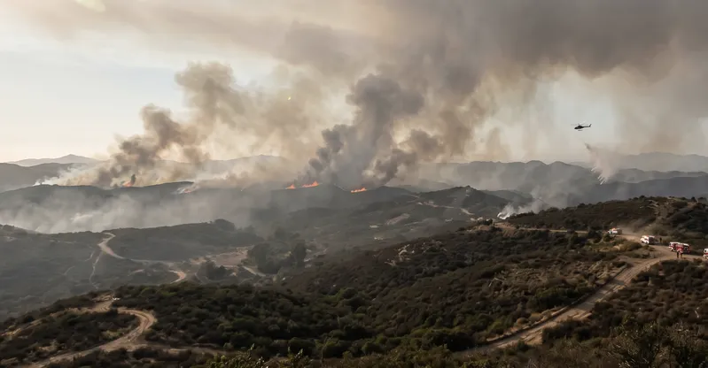
Smoke from a fire in the Otay Mountain wilderness can reach a home in Chula Vista in under an hour. By the time the orange haze is visible from a front porch in Ramona or Alpine, PM2.5 may already be circulating through the house. The live map above shows where fires are burning right now and how far smoke has traveled across San Diego County — so you can see what's actually in the air before you open a window or wait for an alert that may not arrive fast enough.
The live map at the top of this page shows active fire perimeters, smoke plumes, and real-time AQI readings for all of San Diego County, updated continuously from EPA AirNow and Cal Fire. When AQI exceeds 150, stay indoors, switch your HVAC to recirculate, and run a MERV 13 rated filter to protect your family's indoor air.
The live San Diego wildfire map above shows real-time fire perimeters, smoke plume spread, and AQI readings across San Diego County, updated continuously from EPA AirNow and Cal Fire data systems.
San Diego County's wildfire risk is not limited to the October–December Santa Ana season. Dry chaparral fuel conditions and persistent drought patterns keep fire risk elevated year-round.
An AQI reading above 150 is classified as Unhealthy for All — meaning the air is harmful to every person outdoors, not just sensitive groups, and to anyone indoors without proper filtration.
Standard MERV 8 and below filters cannot capture the PM2.5 particles carried by wildfire smoke. The EPA recommends MERV 13 as the minimum rated filter for protecting indoor air quality during smoke events.
Closing windows alone does not stop PM2.5 infiltration. EPA research shows indoor PM2.5 levels reach 55 to 60 percent of outdoor levels in sealed homes without air purification running.
A MERV 13 filter running continuously on your HVAC system at four to six air changes per hour can reduce indoor PM2.5 concentrations by approximately 50 percent during a wildfire smoke event.
Wildland fires account for 52 percent of all PM2.5 emissions in the United States, meaning San Diego's smoke exposure risk extends well beyond locally ignited fires.
The map draws from three data layers. Red dots mark active fire detections from continuous satellite monitoring. Gray plume overlays show where smoke is moving across the county and how concentrated it is at your location. Color-coded circles at monitoring stations display live AQI readings — green for good, yellow for moderate, orange for conditions that affect sensitive groups, red for air that's unhealthy for everyone, and purple for hazardous. Tap any marker for detail. EPA AirNow and Cal Fire both feed the map, so what you see reflects actual conditions today, not a delayed average.
The Air Quality Index runs from 0 to 500, divided into six categories. Good (0–50) and Moderate (51–100) carry little risk for most people. At Unhealthy for Sensitive Groups (101–150), children, older adults, and anyone managing asthma, COPD, or heart disease should reduce time outdoors. Unhealthy (151–200) affects the general population — not just vulnerable individuals. Very Unhealthy (201–300) is serious enough that everyone should move activities inside. Hazardous (301–500) means your HVAC needs to be on recirculate with a high-efficiency filter running. When San Diego County's readings hit the red or purple range today, the smoke outside is already working its way into your home's air.
October and November carry the highest fire risk in San Diego County — when dry offshore Santa Ana gusts push relative humidity below 10 percent and fire can run through dense chaparral faster than most people expect. But fire season doesn't end on December 1st. After Filterbuy spent over a decade manufacturing filters and serving more than two million households across the country, we've watched demand from San Diego-area customers spike in early spring too, when the coastal marine layer retreats and inland valleys dry out faster than the calendar suggests they should. Drought conditions, combined with a wildland-urban interface cutting through communities like Alpine, Ramona, Fallbrook, and Potrero, keep fire risk real in every season. If you've ever noticed smoke in February from somewhere east of Interstate 15, you already know this.
Closing your windows does not seal your home from wildfire smoke. When outdoor AQI climbs above 150, PM2.5 (the fine particles that make wildfire smoke medically dangerous) moves through door gaps, window seals, and HVAC fresh-air intakes without waiting for an invitation. Once inside, your HVAC system recirculates those particles through every room at roughly four to six air changes per hour when the fan runs continuously — the rate ASHRAE recommends specifically for wildfire smoke filtration with a MERV 13 filter. A filter rated MERV 8 or below can't capture particles at wildfire-smoke scale. The EPA recommends MERV 13 as the minimum rating for protecting indoor air from wildfire smoke PM2.5. When the San Diego fire smoke map shows your area in an unhealthy range, your filter rating is doing as much protective work as your closed windows. Probably more.
The seven resources below are the ones we direct San Diego customers to first when fire or smoke is in the forecast. Each covers a specific piece of the picture: live fire tracking, real-time AQI data, evacuation alerts, satellite detection, health guidance, local monitoring, and indoor protection. Three verified statistics follow, giving measurable context to the risk. Bookmark the maps, register for alerts, and check your filter before the next wind event shows up.
"During Santa Ana wind-driven fire events in San Diego County, we consistently see MERV 13 filters from households in fire-prone communities reaching full saturation in 30 days or less — roughly half the normal replacement cycle. That's physical evidence of how much particulate matter moves through homes that most residents assume are protected by closed windows and a standard filter."
The EPA AirNow Fire and Smoke Map is the first tool we direct San Diego customers to when smoke is visible and they need to know what's burning and where it's headed. Built jointly by the EPA and the U.S. Forest Service, the map combines satellite-detected active fire locations with live PM2.5 air quality readings from official monitoring stations — so you see the fire and the smoke impact on a single screen.
To use it effectively in San Diego: zoom to the county, toggle the smoke layer on, and watch the gray plume contours track how far particulate matter has moved from the fire perimeter. The color-coded AQI circles at monitoring stations update throughout the day, giving you current readings by zip code alongside a five-day forecast. If you're in East County communities like El Cajon, Santee, or Lakeside, AirNow's station-level data often shows noticeably different readings from coastal monitors because the marine layer keeps smoke concentrations elevated inland while coastal areas stay cleaner. That granularity matters when you're deciding whether to run your HVAC on recirculate or open the windows.
The map also links directly to current smoke advisories issued by California's air districts, and you can subscribe to AirNow's EnviroFlash email alerts to receive daily AQI forecasts for any San Diego zip code — delivered before 7 a.m. so you can make decisions about outdoor activities for the day.
Source: https://fire.airnow.gov/
Cal Fire's live incident map is the authoritative state record for every active wildfire in California, updated directly from incident commanders in the field. When smoke shows up on the Southern California wildfire map but no local cause is obvious, this tool tells you whether a Cal Fire incident is burning upwind of San Diego and how far the perimeter has grown since the fire started.
The map distinguishes clearly between Evacuation Orders and Evacuation Warnings — two designations that carry very different levels of urgency. An Evacuation Order means law enforcement has determined there is an immediate threat to life and residents must leave immediately. An Evacuation Warning indicates a potential threat where those who need extra time — households with pets, livestock, elderly family members, or mobility challenges — should leave now. Understanding this distinction before a fire starts is the difference between orderly preparation and panicked evacuation.
Individual incident pages include confirmed structure damage counts, agency jurisdiction, air asset deployment, and links to maps showing the fire perimeter at different time intervals. Cal Fire also publishes a seasonal fire potential outlook specific to Southern California, which is worth checking at the start of both fall and spring each year if you live in San Diego County's inland communities.
Source: https://www.fire.ca.gov/incidents
Alert San Diego is San Diego County's official emergency notification system, managed by the Office of Emergency Services and the Sheriff's Department. It delivers emergency alerts via phone call, text, and email to any address you register — your home, workplace, a family member's address, or all three simultaneously. When an evacuation order is issued for a specific zone in Alpine or Escondido, residents registered in that zone receive notification within minutes.
The Alert San Diego app (formerly SD Emergency) is the mobile companion to the system and the most useful single tool for real-time wildfire management in San Diego County. Key features include a live interactive emergency map showing active evacuation zones, road closures, Red Cross shelter locations, and emergency traffic control points. The app's "Know Your Hazards" tool lets you search any San Diego address to identify its wildfire hazard severity zone, flood risk, and earthquake exposure before any emergency develops. The app receives push notifications for new incidents as they're declared.
One detail that trips up households during fast-moving fires: Alert San Diego notifies based on your registered address. If you're at work in Mission Valley when a fire breaks out near your home in Ramona, you will receive the alert for your registered home location. Registering your workplace address as a second location ensures you're informed regardless of where you are when conditions change.
Source: https://www.sandiegocounty.gov/content/sdc/sustainability/news/Wildfire-Preparedness.html
NASA's Fire Information for Resource Management System — FIRMS — delivers satellite-based fire detection data from two instruments: MODIS (Moderate Resolution Imaging Spectroradiometer) on the Terra and Aqua satellites, and VIIRS (Visible Infrared Imaging Radiometer Suite) on the Suomi-NPP and NOAA-20 satellites. Together, these instruments scan the Earth's surface multiple times per day and flag any thermal anomaly that matches a fire signature.
For San Diego County, FIRMS provides a critical window during the first hours of a new ignition, when ground-based reporting may lag behind the actual fire situation. VIIRS data typically becomes available within three to four hours of detection — often before Cal Fire's incident page has been updated with current perimeter estimates. The confidence level displayed for each detection (low, nominal, or high) tells you how certain the satellite data is, which matters when a potential fire appears in a remote chaparral area of Anza-Borrego or the Otay Mountain wilderness before any ground units have confirmed it.
You can set custom fire alert emails through FIRMS for a defined geographic area around San Diego. For households in communities like Ramona, Alpine, or Potrero that sit close to the wildland-urban interface, setting a FIRMS alert for a 50-kilometer radius provides early satellite-level notification that predates most local media coverage.
Source: https://firms.modaps.eosdis.nasa.gov/map/
The CDC's official wildfire safety guidelines cover the full health picture: which populations face the highest risk, what symptoms indicate smoke exposure requiring medical attention, how to protect yourself indoors and outdoors during an active smoke event, and what steps to take after smoke clears. The guidance is written for both healthy adults and the specific groups that face elevated risk — children, older adults, pregnant women, and anyone with asthma, COPD, heart disease, or diabetes.
For outdoor exposure when smoke is present, the CDC recommends NIOSH-approved N95 respirators, noting that standard cloth masks and surgical masks do not filter fine particles effectively. For indoor protection, the guidance explicitly covers setting HVAC systems to recirculate mode, upgrading to high-efficiency filters, creating a designated clean room in the home, and using a portable HEPA air cleaner in the room where your family spends the most time. The CDC also documents when to seek medical care: chest pain, shortness of breath, and worsening symptoms in people with existing lung or heart conditions are the primary triggers for immediate evaluation.
Share this resource directly with elderly parents, family members with respiratory conditions, or caregivers managing children with asthma who live in San Diego County's inland communities — particularly in Escondido, El Cajon, Lakeside, and Santee, where smoke concentrations from easterly wind events are typically highest.
Source: https://www.cdc.gov/wildfires/safety/how-to-safely-stay-safe-during-a-wildfire.html
The San Diego County Air Pollution Control District (SDAPCD) operates one of the most geographically distributed air monitoring networks in Southern California, with stations positioned to capture the dramatic variation in air quality across the county's varied terrain. Monitoring locations include Chula Vista, El Cajon, Escondido, Camp Pendleton, Alpine, Otay Mesa, Kearny Villa Road, and the San Diego central station downtown — giving you data specific to the microclimates that shape San Diego's air quality in a way national systems can miss.
This matters during wildfire events because topography drives smoke behavior in San Diego County. The mountain ridges east of the urban core — Palomar, Cuyamaca, and the Laguna Mountains — channel and trap smoke in valley communities at night when air cools and descends. A fire burning in eastern San Diego County can produce very different AQI readings in Ramona versus La Mesa versus Chula Vista simultaneously, even within the same smoke plume. The SDAPCD's local station network captures those differences where national AirNow data may show an averaged county reading.
The SDAPCD's site also publishes the county's annual air quality report, which documents how many days per year each region of San Diego exceeds federal health standards for PM2.5 and ozone. Reviewing recent years' data for your specific area is a useful exercise before fire season begins, and the SDAPCD's AQI forecast page publishes next-day air quality predictions each afternoon.
Source: https://www.sdapcd.org/content/sdapcd/air-quality.html
The EPA's Wildfires and Indoor Air Quality page is the most thorough single resource available for residential indoor air protection during wildfire smoke events. It covers how smoke enters homes, which actions reduce indoor PM2.5 most effectively, and the step-by-step setup for both HVAC-based filtration and portable air cleaners. It's the guidance we point customers to when they want the full picture beyond filter selection.
For HVAC systems, the EPA's guidance is specific: close the outdoor air intake or set the system to recirculate, upgrade to MERV 13, and switch the fan from "Auto" to "On" so it runs continuously rather than cycling only when the thermostat calls for heating or cooling. Running the fan continuously on "On" mode is what drives the four to six air changes per hour needed to meaningfully reduce indoor PM2.5 concentrations during a smoke event. Without continuous fan operation, even a MERV 13 filter only cleans the air when the thermostat demands a temperature change — which may be infrequent during a cool, smoky October Santa Ana.
The page also covers DIY air cleaner construction using a box fan and one or more MERV 13 filters — the Corsi-Rosenthal design that EPA testing confirmed can reduce indoor PM2.5 by 56 percent in a large room within 90 minutes and by close to 99 percent in smaller rooms within an hour. For households that want a designated clean room during a smoke event, the EPA's "Create a Clean Room" guide walks through choosing the right room, sealing gaps, running a portable air cleaner, and maintaining the space for extended smoke events that may last several days. The page also notes when to replace filters during heavy smoke periods: check monthly, and replace immediately if the filter appears dark brown or black, which during an active fire event may happen in under 30 days.
Source: https://www.epa.gov/emergencies-iaq/wildfires-and-indoor-air-quality-iaq
We've tracked this in filter performance data across high-fire-risk communities, and the pattern holds. Closed windows are a meaningful barrier — just not a complete one. PM2.5 particles pass through door gaps, HVAC fresh-air intakes, and normal building infiltration pathways until a properly rated filter stops them. The homeowners who feel most protected with their windows shut are often the ones most surprised by how much smoke their filter actually caught.
Source: https://www.epa.gov/wildfire-smoke-course/strategies-reduce-exposure-indoors
That's why San Diego's AQI can push into unhealthy territory on days when no local fire is burning. Smoke from fires hundreds of miles away in Central California or the Sierra Nevada drifts south and registers at concerning levels on the county's monitors. The California wildfire smoke tracker tools listed on this page give you visibility into those sources well beyond the county line.
Source: https://www.epa.gov/air-research/wildland-fire-research-reducing-exposures
In our experience serving households across fire-prone communities from Southern California to the Pacific Northwest, the families most at risk are the ones who assumed a standard filter and closed windows were providing protection that MERV 8 media simply can't deliver. The gap between what homeowners believe their filtration is doing and what it actually captures is the invisible problem we've spent more than a decade working to close.
Source: https://www.cdc.gov/climate-health/php/effects/wildfires.html
Our Take on San Diego's Wildfire and Air Quality Risk
San Diego's fire threat doesn't take a winter break. The October wind events make the news — but the dry chaparral covering the county's inland valleys stays combustible well into spring, and drought years compress the breathing room even further.
Serving millions of customers in fire-prone communities has shown us a consistent gap in how homeowners think about wildfire risk. The visible threat gets attention and preparation: the orange sky, the ash on the windshield, the evacuation crawl on the TV. The invisible threat doesn't. A PM2.5 particle is approximately 1/30th the width of a human hair — small enough to enter a closed home without announcing itself, circulating until a properly rated filter stops it. Most MERV 8 filters won't do it.
Most households check the outdoor fire map and call it protection. The map tells you what's burning. Your HVAC filter determines whether what's burning ends up in the air your family breathes indoors. Checking the filter rating — and upgrading to MERV 13 if needed — is the step most San Diego homeowners skip entirely.
What to Do Right Now If You're in San Diego County
Bookmark the live San Diego wildfire map on this page and the EPA AirNow Fire and Smoke Map at fire.airnow.gov as your two primary real-time references during any fire event.
Register for Alert San Diego at alertsandiego.org to receive evacuation zone notifications by call, text, or email. Register your home address and your workplace address. Set this up before smoke appears — not during it.
Download the Alert San Diego app, which delivers a live interactive emergency map, evacuation zone boundaries, road closures, Red Cross shelter locations, and push notifications built specifically for San Diego County conditions.
Check your HVAC filter's current MERV rating. If it's MERV 8 or lower, it cannot protect your household from PM2.5 during a wildfire smoke event. Upgrade to MERV 13 before the next Santa Ana wind event.
Switch your HVAC to recirculate mode when the San Diego AQI live reading goes above 100. Set the fan to "On" rather than "Auto" so it runs continuously, cycling your home's air through the filter four to six times per hour throughout the smoke event.
Plan on replacing your MERV 13 filter monthly during fire season. Heavy smoke events saturate a MERV 13 in 30 days — well ahead of the standard 90-day cycle, and long before the filter looks dirty enough to prompt a change.
Yes. The interactive map at the top of this page shows current fire perimeters, smoke plume spread, and real-time AQI readings across San Diego County, updated continuously from EPA AirNow and Cal Fire monitoring systems. Zoom into any part of the county to check conditions near your neighborhood or zip code.
Readings vary by location and change throughout the day based on wind direction, fire activity, and atmospheric conditions. The map above shows live readings at specific monitoring stations throughout the county. For the most current AQI by zip code, check the EPA AirNow map at fire.airnow.gov or the San Diego APCD's air quality forecast at sdapcd.org.
Four steps make the most measurable difference:
Set your HVAC to recirculate mode to stop it from drawing smoky outdoor air in through the fresh-air intake.
Upgrade to MERV 13 — the minimum the EPA recommends for capturing PM2.5 from wildfire smoke.
Run your HVAC fan on "On" rather than "Auto" so air cycles continuously through the filter at four to six air changes per hour for the duration of the smoke event.
Replace your MERV 13 filter monthly during fire season. Heavy smoke events can fully saturate a filter in 30 days, well ahead of the standard replacement cycle.
The highest-risk window runs from late September through December, when Santa Ana winds deliver hot, dry offshore gusts that strip humidity from the chaparral and push fires rapidly toward populated communities. Fire conditions can develop at any point in the year, though — particularly during drought years when fuel moisture stays critically low from spring through fall.
The EPA AirNow Fire and Smoke Map at fire.airnow.gov is the most reliable tool for tracking active fires and smoke plumes across California and into San Diego County. NASA FIRMS at firms.modaps.eosdis.nasa.gov/map/ provides near-real-time satellite hotspot data from MODIS and VIIRS instruments for early detection. Cal Fire at fire.ca.gov/incidents maintains a continuously updated statewide incident list.
The EPA recommends MERV 13 as the minimum for removing PM2.5 fine particles from wildfire smoke in residential HVAC systems. Filters rated MERV 8 and below allow the majority of wildfire smoke particles to pass through and recirculate. A MERV 13 filter paired with continuous fan operation and recirculate mode achieves four to six air changes per hour, which can reduce indoor PM2.5 by approximately 50 percent. Most residential HVAC systems manufactured after 2005 can accommodate MERV 13 without modification — check your system manual or consult an HVAC technician if you're unsure.
Below 100, most people face limited risk outdoors. Between 101 and 150, children, older adults, and anyone with respiratory or heart conditions should stay in. Above 150, that advisory applies to everyone — and indoors, a high-efficiency HVAC filter stops being optional. At 201 or higher, MERV 13 filtration with the fan on continuous is the baseline for any household member, regardless of age or health status.
MERV 13 is the minimum the EPA recommends for removing PM2.5 from wildfire smoke in residential HVAC systems. Filters below MERV 13 won't adequately capture the fine particles that make wildfire smoke dangerous to respiratory and cardiovascular health.
The map shows you what's burning outside. Your MERV 13 filter controls what enters your home's air.
Santa Ana conditions, persistent drought, and a wildland-urban interface running through residential communities like Alpine, Ramona, and Fallbrook produce smoke exposure events in San Diego County every year. Not occasionally. Every year. When that smoke arrives, your HVAC system runs it through every room on a continuous loop until a properly rated filter stops it.
A MERV 13 rated filter is your most effective indoor air defense during a wildfire event. Set up automatic delivery so you're never running a spent filter when the next smoke advisory rolls in.