Don’t trust the haze to tell you the whole story. When wildfire smoke reaches Fresno, the gray sky is only the part you can see. The particles that actually harm your lungs are far too fine for the eye to catch, and they move indoors right along with you. So we built this page to make the invisible visible. The live Fresno wildfire smoke map below tracks where fires are burning, how smoke is drifting across the Central Valley, and how clean the air is right where you live. Check it before the school run, before a workout, before you open a window. We keep it current through fire season so your family can act on real conditions instead of a guess at the sky.
Where do I see fires and smoke near Fresno? The live map at the top of this page.
What does the AQI number mean? Lower is cleaner air. Above 100, sensitive groups should take care. Above 150, everyone should limit outdoor time.
Why is Fresno smoky with no nearby fire? Smoke travels long distances, and the Valley traps it close to the ground.
Best filter for wildfire smoke? MERV 13, if your HVAC system supports it.
Fastest way to protect your family indoors? Close the windows, run the AC on recirculate, and use a clean, fine-particle filter.
Wildfire smoke reaches Fresno often because the San Joaquin Valley traps air close to the ground.
The map at the top of this page shows active fires near Fresno, where smoke is spreading, and live air quality readings.
Use the AQI as your guide for whether it is safe to go outside in Fresno today.
Smoke can arrive from fires hundreds of miles away, so a hazy sky does not always mean a nearby fire.
Your home is your clean-air space. Close the windows, run the AC on recirculate, and keep a quality filter in place.
A MERV 13 air filter catches the fine particles found in wildfire smoke and is a strong choice for most homes.
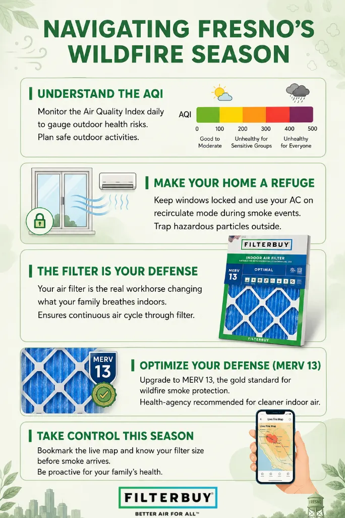
Start with the map at the top of this page. It pulls live fire and smoke data into one view, so you are not hunting across five websites during a stressful morning. Fire icons mark where wildfires near Fresno, CA, are burning right now, and shaded plumes trace where the smoke is heading. The colored dots are ground-level monitors reporting fine particle pollution, the reading that matters most for your health. Treat the map like a weather check. Look in the morning before school or outdoor work, then look again at midday if the wind turns or the smoke forecast shifts.
Fresno feels these events harder than most cities, and geography is the reason. The San Joaquin Valley sits like a shallow bowl ringed by mountains. On calm days, a temperature inversion acts like a lid, holding air near the ground instead of letting it rise and clear, so smoke that drifts in can hang over the Valley for days. Here is the part that surprises people. The sky can turn hazy when there is no fire anywhere near you. Smoke travels hundreds of miles, which means a fire in the Sierra Nevada or far up in Northern California can gray out Fresno without warning. A quick look at how wildfires behave makes clear how their smoke reaches towns so far from the flames.
All of that gets distilled into one number, the Air Quality Index, or AQI. It runs from 0 to 500, and lower means cleaner air. Check the figure on the map for Fresno air quality today, then let it set your caution level. Good and Moderate readings are fine for most people. Once the AQI climbs past 100 into the Unhealthy for Sensitive Groups range, anyone with asthma, COPD, or heart disease should ease up outdoors, and so should young children and older adults. When the map turns red or purple, everyone belongs inside.
Indoors is where you actually have control, and during a smoke event, your home becomes the clean-air space your family counts on. A few moves make a real difference. Close the windows during the worst hours. Run your central system or window AC on recirculate so it stops pulling smoky air in from outside, and set the fan to On rather than Auto so air keeps cycling through the filter. That filter is the piece most households overlook. Its MERV rating tells you how small a particle it can catch:
MERV 8 captures everyday dust and larger pollen and helps keep your system clean.
MERV 11 catches finer particles such as pet dander and many mold spores.
MERV 13 traps the fine particles that make wildfire smoke so harmful, which is why a MERV 13 air filter for smoke is what many Fresno households choose.
Before you jump to a higher rating, check your HVAC manufacturer’s guidance, because not every system is built to handle one. If yours can take it, MERV 13 is the level public health agencies point to for wildfire smoke, and for a typical home, it is the filter we would put in ourselves. We manufacture our pleated filters here in the United States in hundreds of standard and custom sizes, so your replacement fits tight, catches more of what you cannot see, and still lets your system breathe.
After manufacturing filters for over a decade and serving more than two million households, the pattern I see every fire season is the same. People watch what is happening outside and forget that the air they actually breathe is inside their home. When smoke moves into the Valley, your filter is doing real work, and a filter rated for fine particles changes what your family breathes for the next several hours. The households that come through a smoke event best are the ones that treat a fresh filter as basic preparation rather than an afterthought.
— Filterbuy Team
We pulled together the resources our own team checks during fire season. Every one is a government or public health source, and each link is current. Bookmark the ones that fit your household plans.
The EPA and U.S. Forest Service run the Fire and Smoke Map, the most widely used tool for seeing fires, smoke plumes, and live PM2.5 readings near you, with clear steps for when smoke is in the air. Source: AirNow Fire and Smoke Map and Smoke Safety Guidance.
The Environmental Protection Agency explains how to keep smoke from getting inside, covering HVAC settings, portable air cleaners, and safe cleanup after a fire. Source: EPA Guide to Wildfires and Indoor Air Quality.
California’s Air Resources Board walks you through building a cleaner-air room and preparing your household before smoke arrives. Source: Smoke Ready California from the Air Resources Board.
Your regional air district shares Valley-specific guidance and local air quality alerts for Fresno and the surrounding counties. Source: San Joaquin Valley Air District Wildfire Smoke Protection.
The Centers for Disease Control and Prevention covers who faces the most risk and how to protect children, older adults, and people with lung or heart conditions. Source: CDC Safety Steps for Wildfires and Wildfire Smoke.
FEMA’s Ready.gov helps you build an emergency plan, sign up for alerts, and map your evacuation routes before a fire threatens your area. Source: Ready.gov Wildfire Preparedness and Evacuation Planning.
The National Weather Service explains fire weather watches and red flag warnings so you can see dangerous conditions coming. Source: National Weather Service Wildfire Preparedness Resources.
These numbers explain why wildfire smoke earns your attention, and why Fresno feels it as often as it does.
Researchers studying Southern California hospital data found that wildfire smoke punches above its weight. A 10-microgram rise in wildfire-specific fine particles was linked to a 1.3 to 10 percent increase in respiratory hospitalizations, against 0.67 to 1.3 percent for fine particles from other sources. The particles in smoke appear to hit your lungs harder. Source: Wildfire Smoke and Respiratory Health Study, U.S. National Library of Medicine
Fresno’s air problem is well known to the people who measure it. The American Lung Association’s State of the Air report places the Fresno-Hanford-Corcoran metro area among the most polluted in the nation, with failing grades for ozone and for both short-term and year-round particle pollution. Wildfire smoke is one of the forces that drives those particle spikes higher. Source: Fresno-Hanford-Corcoran Air Quality Report Card, American Lung Association
Wildfires are now a fixed part of life across the West. The National Interagency Fire Center counts tens of thousands of them in the United States every year, and recent years have burned roughly 7 to 9 million acres nationally. That smoke does not stay put. It drifts far past the burn scar and settles over valleys like ours. Source: United States Wildfire Statistics, National Interagency Fire Center
Here is our honest take after a lot of fire seasons. The map is genuinely useful, and you should check it often. Watching the smoke, though, will not protect anyone from it. You will spend most of a smoke event indoors, so the air inside your home, not the sky outside, decides how the next few days feel. The Fresno families who ride it out in comfort are rarely the ones with the slickest app. They are the ones who closed the windows early, switched the system to recirculate, and had a filter built for fine particles already in place when the haze rolled in. So use the map as your early warning. Use your filter as your defense.
A little preparation now means you are not scrambling when the next smoke event hits.
Bookmark this page and the Fire and Smoke Map so a current Fresno smoke forecast is always one tap away.
Check the map each morning during fire season, and again at midday when the wind or weather shifts.
Find your HVAC filter size now, before smoke arrives and local stores sell out.
Move up to a MERV 13 filter if your system supports it, so you are ready for fine smoke particles.
Pick one room to keep cleanest, and confirm your AC can run on recirculate.
Replace your filter more often during a smoke event, since heavy particle loads clog it faster.
The fastest way to check is the live map at the top of this page, which shows active fires near Fresno and across the county throughout the day. For official incident details and evacuation information, also check CAL FIRE and your county emergency alerts.
The colored monitors on the Fresno wildfire smoke map report current air quality as an AQI number, and lower numbers mean cleaner air. During a smoke event, recheck it every few hours, since wind and weather can change Fresno air quality fast.
Often, the smoke is not from a local fire at all. Wildfire smoke travels long distances, and the Central Valley’s geography and calm air trap those particles near the ground. A fire in the Sierra Nevada or Northern California can leave Fresno hazy for days.
Let the AQI decide. Good and Moderate readings are generally fine for most people. At Unhealthy for Sensitive Groups and above, anyone with asthma, heart disease, or another risk factor should limit outdoor time. When readings reach red or purple, everyone should stay indoors.
For most homes, a MERV 13 air filter for smoke gives you the best balance of fine-particle capture and airflow, since it catches the small particles wildfire haze is made of. Confirm your HVAC system supports MERV 13 before you upgrade, then change the filter often during smoke events.
More often than usual. Wildfire smoke loads a filter with fine particles fast, so one that normally lasts about 90 days may need changing within a few weeks of heavy smoke. Check it monthly, and replace it once it looks gray and loaded.
You cannot stop wildfire smoke from reaching the Valley, but you can decide what your family breathes once it gets here. Keep this page close through fire season, and pair it with our live Fresno air quality index map for the fuller picture where you live. Then get ahead of the next event. Find your filter size and order U.S.-made pleated filters from Filterbuy, built to catch more of what you cannot see. Cleaner air at home is one filter change away.