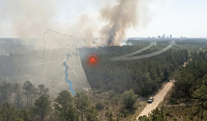
Wildfire smoke reaches Jacksonville quietly, without a burning horizon or an emergency broadcast. By the time the copper haze settles above the St. Johns River tree line, PM2.5 readings have already been rising for hours. This page gives you live fire tracking and real-time AQI data so you can make fast decisions about your family's outdoor plans before the air quality makes those decisions for you.
Florida remains one of the most fire-active states in the country. Pine flatwoods, scrub habitats, seasonal drought cycles, and proximity to Georgia's Okefenokee Swamp make Northeast Florida a persistent smoke corridor from January through May. Fires as far north as southern Georgia and as far west as the Florida Panhandle send smoke into Jacksonville with regularity, sometimes overnight. Use the current Filterbuy forest wildfire and smoke map for Jacksonville, FL to see exactly where that smoke originates and how close it has traveled to your home.
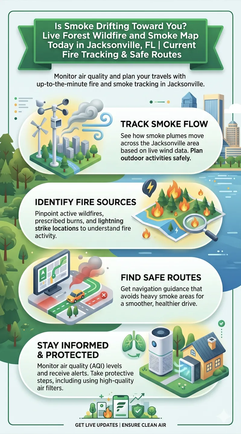
The live forest wildfire and smoke map for Jacksonville, FL is available at fire.airnow.gov, updated in real time by the EPA and U.S. Forest Service. It shows active fire perimeters, satellite-detected hot spots, and PM2.5 air quality readings from Duval County monitoring stations so you can see exactly where smoke is coming from and whether it has reached your area.
For Florida-specific fire conditions and county-level burn bans, the Florida Forest Service reports current activity at fdacs.gov. Check both maps before any outdoor plans from November through May — wildfire smoke reaches Jacksonville overnight with no visible warning, and by the time you smell it, the exposure has already begun.
The current live forest wildfire and smoke map for Jacksonville, FL displays active fire perimeters, real-time PM2.5 air quality readings, and smoke plumes updated throughout the day from EPA, USFS, and NIFC data sources.
Wildfire smoke reaches Jacksonville primarily from Florida's pine flatwoods and scrub systems, the Okefenokee Swamp corridor, and managed burns across North Florida and southern Georgia, often arriving overnight with little visible warning.
An AQI of 101 or higher signals air that is unhealthy for sensitive groups in Jacksonville. At 151 or above, the air is unhealthy for everyone. Stop outdoor exertion and run your HVAC with a high-efficiency filter.
PM2.5 is the key pollutant during wildfire smoke events. Wildfire-generated PM2.5 particles are finer and penetrate deeper into lung tissue than typical ambient particulate matter. A MERV 13 filter is the minimum recommended rating for capturing PM2.5-range particles in a residential HVAC system.
Florida's wildfire season peaks from January through May. Jacksonville residents should treat this window as a monitoring period, checking the live smoke map and local AQI data consistently rather than waiting for visible or detectable smoke.
Children, older adults, and people with respiratory or cardiovascular conditions face disproportionately higher health risk from wildfire smoke exposure. Protective actions, staying indoors, running filtered HVAC, and limiting outdoor time, should begin earlier for these household members than for healthy adults.
The live fire map for Florida pulls data from three sources: the EPA and U.S. Forest Service's AirNow Fire and Smoke Map, the National Interagency Fire Center's incident reporting system, and real-time PM2.5 readings from the Florida Department of Environmental Protection's monitoring stations. Colored circles on the map show current air quality at each location, with blue flame icons marking reported fire incidents and purple markers flagging satellite-detected hot spots. When orange or red circles appear near Jacksonville, particulate matter has reached levels where outdoor activity carries real health risk, even for otherwise healthy adults.
Wildfire smoke doesn't stay near the fire. Fine particles from burning vegetation, specifically PM2.5 particles smaller than 2.5 micrometers, travel hundreds of miles on prevailing winds. Jacksonville sits at the intersection of two reliable smoke corridors. The first runs northeast from central Florida's pine flatwoods and scrub systems, which burn regularly through dry winters. The second flows south from Georgia and the South Carolina low country, where large managed burns and wildfire events generate smoke columns that reach Duval County in under 12 hours when winds cooperate.
Jacksonville's geography complicates the picture further. The city's semi-coastal position and proximity to the St. Johns River marshes mean overnight sea breezes regularly trap smoke near ground level, even on days when afternoon winds push visible haze away. Early morning AQI readings here frequently run worse than what the same day looks like at noon. Check the active wildfires near Jacksonville map before 8 a.m. if you want an accurate read on your morning air, not after conditions have already started to improve.
The Air Quality Index runs on a 0 to 500 scale, with six categories that translate the current number into specific health guidance for Jacksonville residents.
0–50 (Good): Air quality poses little or no risk. Outdoor activity is fine for everyone.
51–100 (Moderate): Acceptable for most people, but unusually sensitive individuals may notice effects.
101–150 (Unhealthy for Sensitive Groups): Children, older adults, and anyone with asthma, COPD, or heart disease should limit prolonged outdoor activity.
151–200 (Unhealthy): Everyone may begin to experience health effects. Reduce outdoor exertion.
201–300 (Very Unhealthy): Health alert. Significant effects are likely for the general population. Stay indoors.
301–500 (Hazardous): Emergency conditions. The entire Jacksonville population is at risk. Avoid all outdoor activity.
During wildfire events, PM2.5 is what matters, not ozone. Wildfire smoke generates extremely fine carbon particles that penetrate deep into lung tissue and can enter the bloodstream. An AQI reading driven by PM2.5 during a Jacksonville smoke advisory represents a more serious health exposure than the same number driven by ozone on a hot summer day. Track both numbers, but let PM2.5 guide your decisions when fire activity is nearby.
A smoke advisory means the Florida Department of Environmental Protection or local health authorities have determined Jacksonville-area air quality has dropped to levels that require action. What you do when that alert arrives depends on who's in your home.
Households with children under 12: Move planned outdoor activities, school pickup, sports, and playground time, indoors immediately. Children breathe faster than adults and take in proportionally more PM2.5 per pound of body weight.
Adults with asthma, COPD, or cardiovascular conditions: Keep rescue medications accessible. Avoid outdoor exertion entirely. Close windows and switch your HVAC to recirculation mode.
Healthy adults: At AQI 101 to 150, limit prolonged outdoor exercise. At AQI 151 and above, stay indoors as much as possible.
For indoor air quality: Run your HVAC system with a MERV 13 or higher rated filter. MERV 13 filters capture particles in the PM2.5 size range that bypass standard MERV 8 filters. Replace your filter after extended smoke events, since loaded filters lose effectiveness faster than the calendar suggests.
"After manufacturing air filters for over a decade and serving more than two million households, we can tell you firsthand that wildfire smoke events produce a specific kind of filter loading that most homeowners miss. PM2.5 particles from wildfire smoke are finer and stickier than standard household dust — they penetrate deeper into filter media and saturate the fibers faster. During an active smoke advisory in Florida, a MERV 13 filter that would normally last 60 to 90 days may need replacement in 30. The filter is doing its job. That's exactly what it should look like after protecting your family from wildfire smoke."
The EPA and U.S. Forest Service's joint real-time tool is the first place to check when smoke is in the air and no advisory has arrived yet. It layers PM2.5 readings from thousands of regulatory and crowdsourced monitors alongside satellite-detected fire hot spots, NOAA smoke plumes, and active fire perimeters on a single clickable map. Clicking any circle near Jacksonville opens a dashboard showing current AQI, same-day air quality trend, and health recommendations. Pair the free AirNow mobile app with EnviroFlash email alerts at enviroflash.info to get notified before smoke reaches your neighborhood.
Source: https://fire.airnow.gov/
The NIFC publishes daily Incident Management Situation Reports listing every active large fire in the United States by geographic area, containment status, and acres burned. For Jacksonville, the Southern Area section covers the Florida and Georgia fires most likely to send smoke into Duval County — when that section shows elevated first-quarter activity, smoke corridors toward Jacksonville are open. The InciWeb portal at inciweb.wildfire.gov adds incident-level maps, operational updates, and evacuation notices for any named fire. Bookmark both at the start of each fire season.
Source: https://www.nifc.gov/fire-information
The Florida Forest Service holds primary legal responsibility for wildfire suppression statewide and reports active fires by county, including Duval and the surrounding Northeast Florida counties. The page also publishes Fire Readiness Levels (FRL 1–5) for each district — at FRL 3, burn restrictions are active; at FRL 4 or 5, resources are at or near full commitment and smoke risk climbs sharply. Note: as of April 2026, the NIFC has predicted above-normal wildfire potential for Florida through at least June, with 20 counties under active burn bans. Check current conditions at fdacs.gov before any outdoor plans during dry season.
Source: https://www.fdacs.gov/Forest-Wildfire/Wildland-Fire/Current-Wildfire-Information
Where most air quality resources define AQI numbers, this EPA course explains what PM2.5 actually does inside the body — how fine particles deposit in lung tissue, enter the bloodstream, and trigger cardiovascular and neurological responses. It also covers why wildfire smoke is a distinct physiological threat from typical ambient PM2.5, and which populations face the greatest harm. Population-specific activity guides that translate AQI categories into concrete outdoor and indoor recommendations are linked directly from this page and designed to be printed and kept accessible throughout fire season.
Source: https://www.epa.gov/wildfire-smoke-course/health-effects-attributed-wildfire-smoke-0
Organized around the three phases of a smoke event — preparation, active exposure, and recovery — this is the most actionable federal guidance available for Jacksonville families. Key instructions cover setting up a clean-air room with a sealed HVAC system running a high-efficiency filter, using only NIOSH-approved N95 respirators outdoors (cloth and paper masks do not filter PM2.5), and specific steps for children, pregnant women, and people with asthma or COPD. Read this before April each year, not after an advisory makes it feel urgent.
Source: https://www.cdc.gov/wildfires/safety/how-to-safely-stay-safe-during-a-wildfire.html
The Florida Department of Environmental Protection maintains the Florida Spatial Air Quality System (SAQS), which includes monitoring stations operated directly by the City of Jacksonville and Duval County — making this the most locally specific real-time air quality tool on this list. The interactive map updates throughout the day with PM2.5, ozone, and other pollutant readings. During a smoke event, cross-referencing this map against fire.airnow.gov gives you two independent ground-level confirmation layers for Jacksonville's actual air quality conditions.
Source: https://floridadep.gov/air/air-monitoring/content/air-quality-today
Read this page before using any other resource on this list. It defines the six AQI categories, explains which pollutants are tracked, and describes the NowCast algorithm that keeps AQI readings responsive to rapidly shifting smoke conditions in near real time — useful in Jacksonville, where a morning reading of 80 can climb to 145 by noon as a plume moves closer. The page also links to activity guides by population group that answer the questions that matter most during a smoke advisory: at what AQI children should stop playing outside, and when a MERV 13 filter becomes the right call indoors.
Source: https://www.airnow.gov/aqi/aqi-basics/
The EPA's 2020 National Emissions Inventory found that wildland fires generated roughly 52 percent of all PM2.5 emitted across the United States that year. That figure reshaped how we think about indoor air protection. For years, vehicle exhaust and industrial emissions carried the conversation as the dominant particulate threats. The data showed that wildfire smoke had surpassed both, becoming a larger driver of dangerous fine particle pollution than any other single source in the country. For Jacksonville families during fire season, the practical takeaway is simple. Your air filter works harder during a smoke event than at any other point in the year.
Source: https://www.epa.gov/air-research/wildland-fire-research-reducing-exposures
The National Interagency Fire Center's 2023 Annual Report documented 56,580 individual wildfires across the country, burning a combined 2,693,910 acres. The Southern Area, which includes Florida and Georgia, consistently accounts for a significant portion of national fire occurrence, with activity peaking in the first quarter of each year when Florida's dry season is at its driest. This is not a western-states story for Jacksonville residents. Northeast Florida's pine flatwoods are precisely the kind of fire-receptive fuel system that ignites fast and produces heavy smoke before containment crews can establish control lines.
Source: https://www.nifc.gov/fire-information/statistics/wildfires
EPA research on wildfire smoke exposure found that health vulnerability to PM2.5 is not evenly distributed across age groups. Risk runs higher during childhood and from middle age through older adulthood than during young adulthood, meaning the family members most likely to be home during a Jacksonville smoke advisory are also the most physically vulnerable to what they're breathing. Children breathe more air relative to their body weight and carry developing respiratory systems that PM2.5 damages more readily. Older adults are more likely to have underlying conditions, heart disease, reduced lung function, or diabetes, that make smoke exposure harder for the body to manage. Understanding who in your household is most at risk before a smoke advisory hits changes how quickly you act when one arrives.
Source: https://www.epa.gov/wildfire-smoke-course/who-increased-risk-health-effects-wildfire-smoke-exposure
Jacksonville isn't a wildfire city the way Los Angeles or Boise is. There are no dramatic hillside evacuations, no news helicopters over the suburbs. Instead, Jacksonville gets smoke drifting overnight from the Okefenokee, from managed burns south of Gainesville, from fire clusters in the Osceola National Forest. The AQI climbs past 130 before any alert goes out. Children head to morning recess, residents run their usual routes, and the harm accumulates unseen.
That invisibility is exactly what this map exists to solve. Jacksonville residents have never had tools built specifically for the city's fire geography and smoke corridors, until now. A live Florida forest fire map, real-time PM2.5 data from local DEP monitoring stations, and AQI guidance tied to your household's specific risk profile give you a genuine head start during smoke season. Use them consistently, not only when the smell gets obvious. By the time wildfire smoke is detectable in Jacksonville, the exposure is already hours old.
Bookmark the AirNow Fire and Smoke Map and the Florida DEP Air Quality Today page. Check both before outdoor plans from November through April, the height of Florida's dry season.
Sign up for AirNow EnviroFlash email alerts tied to your Jacksonville zip code. The service sends you a notification whenever the AQI crosses a threshold you set, before you ever smell smoke.
Upgrade your HVAC air filter to MERV 13 ahead of fire season. A MERV 13 filter captures PM2.5-range particles that flow straight through standard MERV 8 filters. Keep a spare on hand, since smoke events accelerate filter loading faster than a normal schedule accounts for.
Know your household's risk profile. Identify any family members with asthma, COPD, cardiovascular conditions, or who are pregnant, since these individuals need to act earlier and at lower AQI thresholds than healthy adults.
Create an indoor air plan for smoke events. Pick one room you can seal with closed windows and run as a clean air space with a MERV 13-filtered HVAC system or a portable air cleaner on high AQI days.
Use the live wildfire map on this page or visit fire.airnow.gov to see current fire incidents within and around Northeast Florida. The AirNow Fire and Smoke Map pulls data from the National Interagency Fire Center and displays blue flame markers for reported fires and purple markers for satellite-detected hot spots. The Florida Forest Service's Current Wildfire Information page at fdacs.gov reports state fire activity organized by county, including Duval, Clay, St. Johns, Nassau, and Baker counties in the Jacksonville metropolitan area.
The current AQI for Jacksonville is available in real time at fire.airnow.gov and at the Florida DEP's Air Quality Today map. During active smoke events, the AQI reflects PM2.5 readings from monitoring stations in Duval County. An AQI of 0 to 50 is Good. At 51 to 100, conditions are Moderate. At 101 to 150, the air is Unhealthy for Sensitive Groups. Above 150, the air is Unhealthy for all Jacksonville residents, and above 200 it is Very Unhealthy.
On the AirNow Fire and Smoke Map, circles indicate air quality readings. Circle size reflects the type of monitor reporting the data, with larger circles representing regulatory-grade monitors and smaller circles representing crowdsourced sensors. Circle color follows the AQI scale: green (Good), yellow (Moderate), orange (Unhealthy for Sensitive Groups), red (Unhealthy), purple (Very Unhealthy), maroon (Hazardous). Click any circle to open a popup showing current AQI, PM2.5 concentration, health recommendations, and same-day air quality trend data for that location.
Wildfire smoke can travel hundreds to thousands of miles from the fire origin. Smoke from large western U.S. wildfires has reached the East Coast multiple times in recent years. For Jacksonville specifically, the most common smoke sources sit within 50 to 400 miles: North Florida fires, the Okefenokee Swamp in Georgia, central Florida pine flatwoods, and prescribed burn activity across the Southeast. Under favorable wind conditions, smoke from these sources can reach Duval County in under 12 hours.
During a wildfire smoke advisory, a MERV 13 filter is the minimum rating recommended for capturing PM2.5-range particles in a residential HVAC system. MERV 8 filters, the most common rating sold at hardware stores, do not capture PM2.5 effectively. MERV 13 filters capture particles in the 0.3 to 1.0 micron range that carry the greatest health risk during smoke events. Check your HVAC system's specifications before upgrading, since some older units are not designed for the increased airflow resistance of higher-MERV filters.
A smoke advisory issued by the Florida DEP or local health authorities means air quality in the Jacksonville area has dropped to levels where action is recommended. Advisories typically coincide with AQI readings above 100, the Unhealthy for Sensitive Groups threshold, but may also be issued during periods of heavy visible smoke regardless of AQI monitor readings. When a smoke advisory is active, sensitive groups should avoid outdoor activity, and all residents are encouraged to limit outdoor exertion and run HVAC systems with high-efficiency filters.
Florida's primary wildfire season runs from late November through April, with peak fire activity between January and May. This period lines up with the state's dry season, when fuel moisture is lowest and fire conditions are most favorable. Jacksonville sits at the northern edge of the Florida Peninsula, within range of fire corridors running north through the Okefenokee Swamp and south through the Osceola and Ocala National Forests. Spring often brings the most significant smoke events to Northeast Florida, when large prescribed burns and escaped wildfires occur simultaneously across the region.
Set up free AQI email alerts through AirNow's EnviroFlash service at airnow.gov, with your Jacksonville zip code and the AQI threshold that fits your household. The Florida DEP Air Quality Today map updates throughout the day with Duval County monitor readings. NOAA Weather Radio and the National Weather Service Jacksonville office issue smoke and air quality alerts that appear in most weather apps. The City of Jacksonville's Environmental Quality Division at jacksonville.gov also maintains ambient air monitoring information specific to Duval County.
The map tells you what is happening outside. Your HVAC filter determines what happens inside. When wildfire smoke reaches Jacksonville and pushes the AQI above 100, running a MERV 13 or higher air filter in your HVAC system is the single most effective step you can take indoors. MERV 13 filters capture the PM2.5-range particles that standard filters miss, the same fine particles that carry the greatest health risk during smoke events.
Every Jacksonville household is different. Filter sizes vary. HVAC systems vary. The right filter for your home is the one that fits correctly, carries a MERV 13 rating or higher, and gets replaced on schedule, especially after extended smoke events when filter loading accelerates.